Students at ENSTA Bretagne complete their course with an end-of-study project. They spend several months working on an engineering assignment under the supervision of their internship tutor. At the end of this assignment, they produce a written thesis which they present before a panel made up of faculty staff and examiners with industrial and scientific backgrounds.
This page presents examples of end-of-study internships completed in the sphere of Hydrography and Oceanography.
Examples of end-of-study projects
Estimation des flux d'O² et de CO² à l'interface air-eau, en milieu contrôlé
Stage de fin d’études réalisé à l'institut méditerranéen d'Océanologie par Domitille C., Formation d’ingénieur spécialité hydrographie océanographie, Promotion 2024
Extrait :
"Les flux de gaz sont primordiaux à estimer pour pouvoir étudier différents phénomènes et processus climatiques. L’objectif de ce stage est de diminuer l’incertitude des mesures des optodes à oxygène de chez Aanderaa® utilisées dans le programme BCG-Argo, afin d’estimer les flux de pCO2 , de pO2 et de chaleur en soufflerie LASIF, un milieu contrôlé permettant de reproduire des expériences."
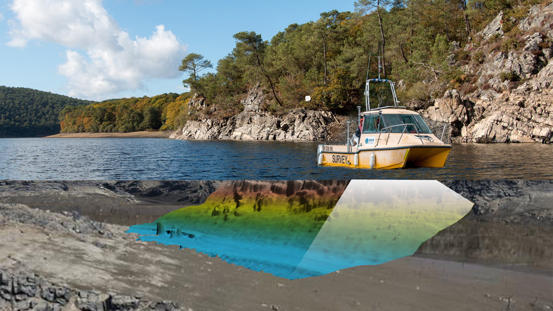
Elaboration d'un protocole d'analyse des données issues d'un profileur acoustique larges bandes visant à la classification des organismes micronectoniques migrants
Stage de fin d’études réalisé au laboratoire IRD par Arnaud C., Formation d’ingénieur spécialité hydrographie océanographie, Promotion 2024
Extrait :
"Mon projet de fin d’études s’inscrit dans le cadre du projet ANR APERO et de sa campagne éponyme mise en place pour « Estimer la production, l’export et la reminéralisation de la matière biogène marine : de la surface à l’océan profond ». Son but est d’étudier l’océan et sa capacité à être une pompe biologique de carbone. Lors de cette campagne des sondeurs acoustiques monofaisceau appelés "profileurs acoustiques" ont été déployés au sein de la colonne d’eau. Les transducteurs utilisés sont larges bandes. C’est-à-dire qu’ils récoltent des informations sur une gamme de fréquences et non une fréquence ponctuelle. Ces acquisitions innovantes permettent d’observer individuellement les organismes évoluant sous la surface et de les associer à une signature fréquentielle.(...) L’objectif est de travailler sur un protocole de traitement des données acoustiques de la campagne APERO. Pour cela, il sera nécessaire de prendre en compte l’ensemble des subtilités apportées par l’usage des profileurs acoustiques larges bandes."
The occurrences and drivers of the observed small-scale surface variations in the Southern Ocean
End of studies internship done at LOPS, by Agathe C., general engineer training, class of 2021
Extract:
"This region is a transition zone between cold/fresh polar water near Antarctic coast and saline/warm subtropical water north of the ACC which is structured
in multiple thermohaline quasi-zonal fronts, varying in location, duration and size. Using 27 years of thermosalinograph measurements along a route between Hobart in Tasmania
and the french base Dumont d’Urville, this report aim is to document (sub)mesoscale thermohaline structure and associated processes at the ocean surface in the Marginal Ice
Zone, south of 60°S."
Development of a new method to detect tropical cyclones centers
End of studies internship done at IUEM, byFlora G., general engineer training, class of 2021
Extract:
"Predicting the intensity and track of tropical cyclones (TC) is nowadays very important to reduce the damage caused by these extreme events. The crucial parameters for improving TC forecasts depend on the position of the tropical cyclone center. Synthetic Aperture Radar (SAR) images provide new observations and estimates of TC-generated winds speed and direction. In this report, a new method will be implemented to calculate the position of TC centers from SARderived wind directions."
Sonar internal waves
End of studies internship done at Stockholms universitet, by Gaspard G., general engineer training, class of 2019
Extract:
“The purpose of this study is to observe internal tides in the ocean by using sonar technology. While the dynamics of internal waves mainly take place in the ocean interior, they also have a small surface expression. We have used the High Resolution Empirical Tide Model, based on satellite altimetry, to compute this surface expression for theM2semi-diurnal tide globally. Based on vertical mode decomposition, we have then estimated the correspondingmode-1 interior isopycnal displacement. On the basis of this knowledge, we explored two acoustic datasets.”
Internal tides characterization on the Abrolhos Bank and the Victoria-Trindade ridge in the context of the SWOT Brazil project
End of studies internship done at LEGOS, CLS, Mercator Ocean International, by Perrine B., general engineer training, class of 2019
Extract:
"In the ocean, internal tides generation occurs when barotropic flows interact with strong topographic gradient, like ridges, in a stratified ocean, which create isopycnal heaving at tidal frequency. Internal tides can dissipate locally or after thousands of kilometres of propagation, whereas their dissipation produces vertical mixing at centimetric to millimetric scales. Their centimetric signature in sea surface height is measured by altimetry. How to separate these scales from (sub)mesoscale circulation is a challenge for both ocean models and for the future SWOT mission, which will provide altimetry data at resolutions never reached before on a large swath. This work contributes to better understand internal tides properties and their interaction with small scale circulation by using already existing altimetry data and a 1/36° resolution NEMO regional simulation to study the Vitoria-Trindade ridge in the South Atlantic, which has been identified as hotspot for internal tides generation."
Processing of AUV data and extraction of backscatter
End of studies internship done at CSIC, by Morgan P., general engineer training, class of 2019
Extract:
« During the INSIGHT-Leg 1 cruise in which I participated, high-resolution bathymetric data at depths up to 5000m were obtained through the use of an AUV, as well as geological and geophysical data obtained from R / V "Sarmiento de Gamboa". The rest of the internship was dedicated to the processing of the data acquired by the AUV ».
Study of the motion of the Argentière glacier by GNSS data
End of studies internship done at ISTerre, by Auriane H., general engineer training, class of 2019
Extract:
" Since 2007, GPS stations record the movements of the Argentière glacier. GPS data processing, which was first based on a static positioning (positions averaged every 6h), is now based on a kinematic positioning (positions computed from the simultaneous record that is made of visible satellites every 30s). Kinematic positioning has a better temporal resolution than the static one.During this internship, GNSS data have been processed via the software TRACK, and Python scripts have been developed to compute vertical displacements and horizontal speeds. Resulting time series have been compared to various observations in order to better understand the glacier’s movements"


news